The North Devon section of the coast path passes through the remote coast of North Exmoor, passing through Combe Martin and the popular resort of Ilfracombe. There are many excellent beaches on this part of the coast, as well as the pretty village of Clovelly and the remote coast near Hartland.
 |
 |
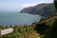
| This walk covers much of the spectacular Exmoor coastline. It begins from the town of Lynmouth in a deep valley of the river Lyn and immediately climbs east along the spectacular cliffs, past the lighthouse at Foreland Point and continuing around Contisbury Cove. The walk soon enters woodland that covers the top of the cliffs and continues east through the quite woodlands passing the tiny Culbourne church and coming into Porlock Weir to the western edge of Porlock Bay. The walk continues to finish in the village of Porlock a short distance inland.
|
|
 |
 |
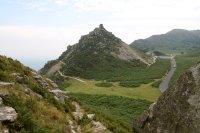
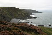
| This walk takes in the highest sea cliff in England, Great Hangman, at 318 metres high. The walk begins from the beautiful town of Lynmouth in the heart of Exmoor and climbs steeply to it's sister at the top of the cliff, Lynton. From here you head west through the spectacular Valley of Rocks and on to Lee Bay and Lee Abbey. The walk continues west past the beautiful wooded Woody Bay and on via lovely heathland to Great Hangman and down to Combe Martin.
|
|
 |
 |
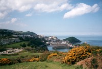
| This walk begins in the popular resort of Ilfracombe. The path climbs out of Ilfracombe to Hillsborough, giving excellent views back to Ilfracombe. From here the path passes Hele Bay then rounds the coast to the small Harbour at Watermouth before rounding the coast into the town of Combe Martin.
|
|
 |
 |
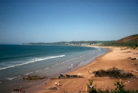
| This walk begins in the popular resort of Ilfracombe. The path climbs out of Ilfracombe onto the spectacular National Trust owned Torrs Walk into the village of Lee. After Lee the path passes the spectacular headlands of Bull Point and Morte Point before arriving at Woolacombe. Woolacombe has a wonderful sandy beach, popular with surfers, spreading for a couple of miles to the south.
|
|
 |
 |
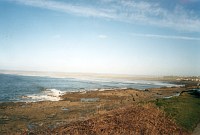
| This walk takes in two superb blue flag beaches. Starting in the popular resort of Woolacombe, you can choose to walk along the sandy beach or on the cliffs behind for around two miles as far as Putsborough Sands. The path then rounds the spectacular headland of Baggy Point into the pretty village of Croyde, where there is a superb beach.
|
|
 |
 |
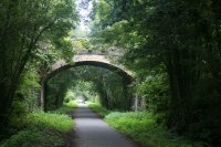
| This walk follows the Tarka Trail from Barnstaple, the principal town of North Devon, west along side the river Taw. The walk follows the course of the old Barnstaple to Ilfracombe railway line and offers fine views of the river for much of the walk. |
|
 |
 |
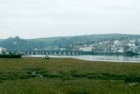
| This walk follows the route of the old railway line from Barnstaple to Bideford, making it a flat walk. The South West Coast Path and Tarka Trail are both the same path along this part of the coast, and the walk starts with good views of the river Taw. As you reach Instow, the river Taw and Torridge meet, flowing out to see. Rounding the corner from Instow, there are views over to Northam, before passing under the A39 into Bideford.
|
|
 |
 |
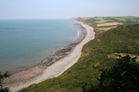
| Starting from the town of Bideford, on the banks of the river Torridge, the path follows the Torridge Estuary north through Northam and Appledore, with it's working ship yard before joining the coast. Shortly after Appledore, the path enters the Northam Burrows Country Park and rounds the coast, giving views towards Clovelly. The beach at Westward Ho!, is dominated by the Pebble Ridge, which protects the low lying land behind from flooding.
|
|
 |
 |
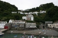
| This walk begins in Westward Ho! with it's rocky and sandy beach and as you head west the walk initially follows the route of an old railway line but soon becomes very hilly with a large number of ascents and descents but stunning views. You soon pass through the lovely village of Bucks Mills and follows the Hobby Drive west to end in the unique village of Clovelly, with its very steep and winding cobbled streets and many pretty cottages.
|
|
 |
 |
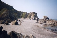
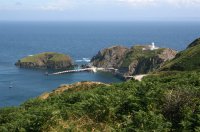
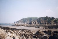
| This walk begins from the remote location of Hartland Quay and follows the impressive rocky coast north to Hartland Point with it's lighthouse and views to Lundy Island, 12 miles away. The walk continues east along this beautiful rocky coast, passing the beautiful Mouthmill beach and Blackchurch Rock and on to the unique village of Clovelly.
|
|
 |
 |
| This is perhaps the longest, toughest and most spectacular walk along the South West Coast Path. It begins from the remote Hartland Quay and follows the coast south for around 16 miles to the popular resort of Bude. On the way you will climb to the top of the cliffs and then back down to sea level many times, but this makes for some spectacular scenery and numerous waterfalls. The walk passes through no villages or towns on the way and so is very remote. |
|