 |
|
|
| Distance : 10 miles | Grading : +++++ | OS Sheet : 126 |
This walk begins from the remote location of Hartland Quay and follows the impressive rocky coast north to Hartland Point with it's lighthouse and views to Lundy Island, 12 miles away. The walk continues east along this beautiful rocky coast, passing the beautiful Mouthmill beach and Blackchurch Rock and on to the unique village of Clovelly. Note that this walk passes through a remote area, with limited opportunities for refreshment.
This walk begins from Hartland Quay, some distance from Hartland. From the A39 (Atlantic Highway) if heading west from Barnstaple and Bideford, turn right onto the B3248 just after the turning for Clovelly at Clovelly cross and follow this road into Hartland. From the south take the left turn onto the B3248 when signed, around 12 miles north of Bude and around 3 miles before Clovelly. Once in Hartland if coming from Barnstaple and Bideford continue straight on along the road, signed for Stoke. From the south, on reaching the square take the road to the left, signed for Stoke (there is a small one way area). This road has some single track sections and one steep hill, so care is needed. You pass the entrance to Hartland Abbey on the right and keep going into Stoke, with it's very tall church tower. Go straight on here, with the church to your right and continue along the road (signed for Hartland Quay). The road descends to the quay and hotel. The last 1/4 mile of the road is private and you must pay a toll to use it (£2 at the time of writing). There is a free car park just above the hotel or another at lower level, but this may be reserved for users of the hotel or pub only so do check first.
Due to the remote location, public transport access for this walk is difficult. There is a bus service to Hartland from both Barnstaple and Bideford and a less frequent service from Bude to the south. From Hartland you'll need to walk along the road to Stoke (there is no pavement, but generally there is not much traffic) and continue along the road to Hartland Quay. In total you'll need to walk a little over two miles from Hartland to reach the start of the walk. You may prefer to call a taxi - one of the pubs or shops in Hartland should be able to provide a number, but this may be costly, as I don't believe there is a taxi firm based in Hartland.
The nearest accommodation to Hartland Quay is the Hartland Quay Hotel, right on the coast path. There is a large camp site and bed and breakfast available at Stoke Barton Farm, around half a mile from Hartland Quay and accessible via footpaths across the fields (it is signed from the coast path, just aim for the tall church tower and stick to the mowed paths over the fields). Otherwise there is a slightly larger choice of accommodation in Hartland or Bude.
Hartland Quay is an interesting and beautiful place. The hotel includes a pub and a ship wreck museum and there is a small shop and toilets opposite. Be warned during the winter months there are no facilities along the coast path all the way to Clovelly, so be sure to stock up (if the shop or pub are open!). In the summer there is often a snack van and/or ice cream van in the car park at Hartland Point. Hartland Quay itself no longer exists. When the railway arrived in Bideford, and road links improved, the cost of maintaining the quay at Hartland against the enormous forces of the sea here meant the quay was no longer feasible and now only the pub and hotel remain.
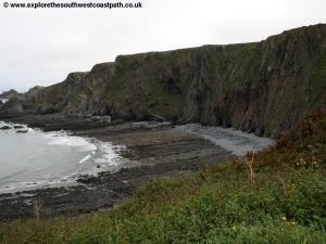
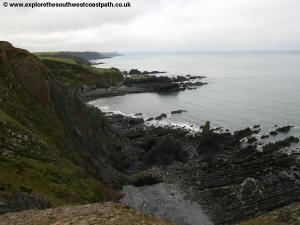
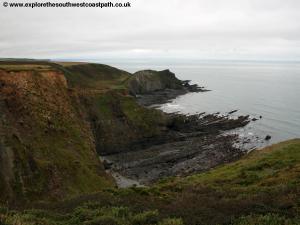
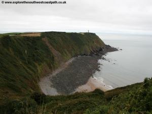
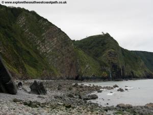
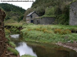
From Hartland Quay you initially follow the steep road up from the hotel, to just before you reach the toll gate where you turn left and then follow the path north, past some stone ruins to the right. The beach to the left is rocky, as is most of the coast in this area. It is said the area around Hartland Point has an average of around 10 ship wrecks for each mile due to the the rough seas combined with these sharp rocks that make navigating this part of the coast by boat a dangerous business! In land the tall church tower of the church in Stoke is a landmark you'll be able to see for much of the walk. After the ascent out of Hartland you follow the cliff tops and then descend back down to into a valley where the old white cottage of Blackpool Mill can be seen (I believe it is now holiday cottages). You have to head briefly inland here to a bridge over the stream then pass beside the mill and back to the coast path. Two impressive waterfalls tumble over the cliffs onto the beach below just north of here and you get good views of these as you descend down to the mill. There is access to the pebble and rock beach, but the coast path continues north, soon climbing over the next cliff and back down to the little bay beyond where the two waterfalls can be seen. You pass above the waterfalls on the coast path and have fine views back to the beach (Blegberry Beach), which is mostly rocks, although there is a very small amount of sand in places.
Beyond, the path climbs and rapidly descends once more to Gull Rock and another rocky beach. Unusually, the coast path ahead goes behind the next hill (although there is a very rough path over the top if you prefer), briefly limiting views of the coast. Once you have views of the coast again you can see ahead to the next little headland (known as Cow and Calf) and the light house of Hartland Point can be seen just beyond. You have to head a little inland again here to cross another stream that leads to a waterfall onto the beach and then take the path that climbs back up on the other side. You continue to gain height and as you do so get better views back along the coast. You soon pass a memorial to the passengers of the Hospital Ship Glenart Castle, that was sunk during World War I, 20 miles off the coast from the memorial - a sad reminder of the number of lives lost at sea in this area.
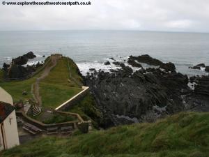
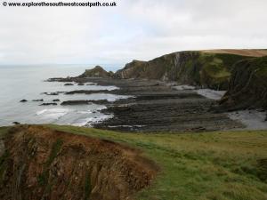
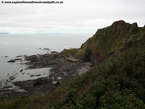
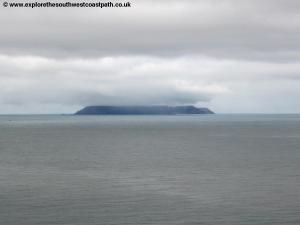
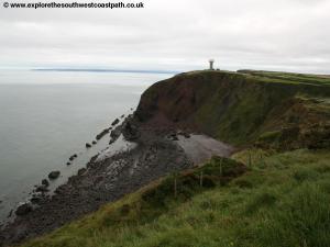
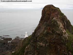
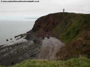
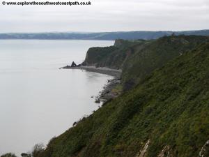
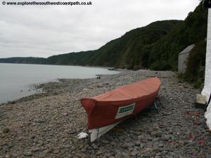
The path continues at a fairly high level now to Hartland Point. The coast path doesn't go right out onto the headland, but there is a path on the headland to a view point. Here you can see Lundy Island, some 12 miles off the coast. Lundy Island can be visited and there are ferries from Clovelly, Bideford and Ilfracombe during the summer. On a clear day you can also see the coast of Wales beyond. The light house is not open to the public and there is no public access on the road down to the light house. Round the coast from the headland and you can see the odd structure topped with a dome on the next cliff, a radar station. The coast to the left continues to be particularly impressive as you follow the track round to the car park at Hartland Point. During the summer months you can often find a snack van and/or ice cream van in the car park if you are in need of refreshment. Beyond the car park the coast path soon narrows back to a path again as it passes Barley Bay and then rounds the Radar Station on the top of the cliff. Ahead you have a beach, Shipload Bay, presumably a reference to the smuggling that was once rife along much of the South West coast. At low tide this is a fine sandy beach, and it's remote location means it's never crowded. There is a path leading down to the beach, but access is difficult and if you choose to take the path, great care must be taken.
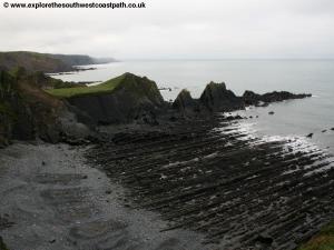
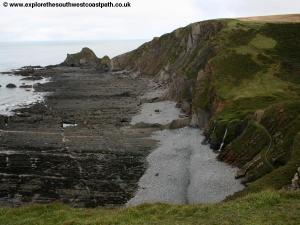
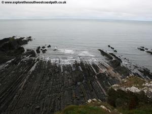
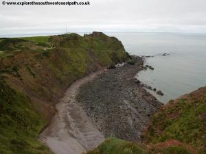
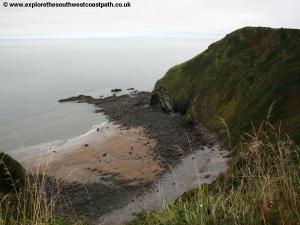
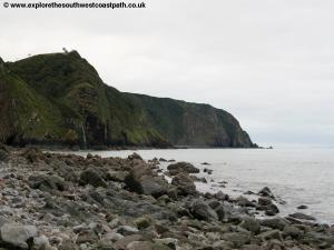
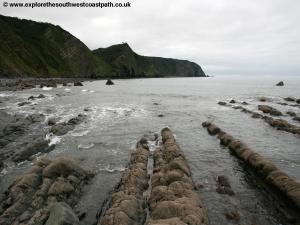
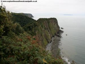
Keep to the coast path as it rounds the back of this beach and continues along the edge of fields for a short period. Where the hedges allow, you have fine views over the Bristol Channel to Lundy 12 miles away and the coast of Wales nearly 50 miles beyond whilst to the east you can follow the coast around right round to Baggy Point near Woolacombe. Continue on the coast path, there are now several miles without any significant ascent or descent! You have views of the headland ahead, Chapman Rock and beyond the beautiful cliffs at Blackchurch Rock, with the large rock and arch at the base of the cliffs. You pass another memorial, this time to the crew of a Wellington Bomber that crashed on these cliffs in 1942, during World War II. Soon the path begins to descend down to another valley with a stream. A path inland follows the valley to the village of Brownsham, half a mile or so inland. The coast path now descends down to the base of this valley and this time you must cross the stream via a very make-shift pile of rocks (the water is shallow so easy to walk through if you don't mind getting your feet wet). If you can spare the time though I strongly recommend exploring the beach below before taking the coast path away from the beach. The rock and pebble beach has some amazing geology, and if the tide is low enough you can go up to the double arched Blackchurch Rock at the base of the cliffs. This is a truly beautiful and un-spoilt location.
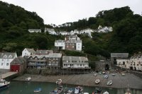
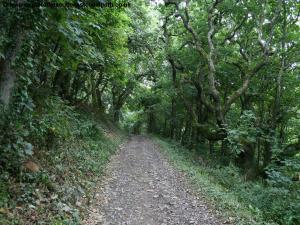
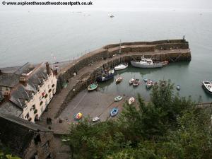
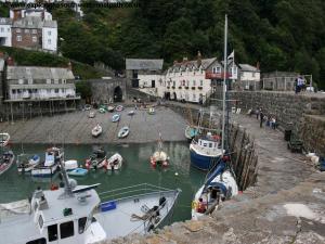
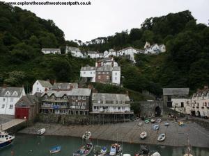
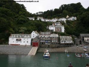
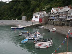
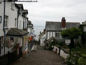
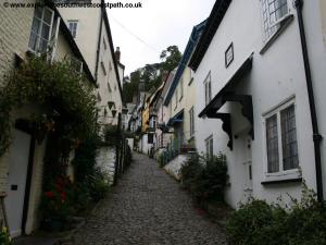
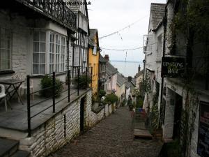
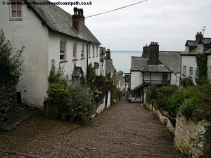
Returning to the coast path ruins of the old Mouth Mill can be seen a little inland beside the stream, but the coast path takes another steep climb into woodland above the bay. Take the path to the left side of the stream as it soon enters woodland. At the junction of paths ahead keep left. Keep along the wide track through this lovely wooded area with occasional views out to sea and back to the spectacular cliffs and beach below. After about a mile and half you pass a lovely wooden carved covered seat and soon take field edge paths on the landward side of the woodland through the edge of Clovelly Court. You pass through a couple of fields until the path turns to the right back through woodland. To the left is the access road to the harbour. It is a steep and narrow used and mainly only used by the land rover shuttle between the harbour and visitor centre which you may see and hear operating. You soon have to join this road and go straight on up hill along the road until you have the main cobbled street down into Clovelly on the left. Clovelly is a very touristy village but is still very beautiful and well worth exploring. The very steep main street is pedestrianised and the residents and business often use sledges to get goods up and down the hilly cobbled street. The white-washed houses are beautiful and at the bottom of the hill is the harbour, with a hotel, numerous houses and a little further along the beach is a waterfall. At the top of the hill is a visitor centre including a cafe.
From the visitor centre car park there are several buses a day Monday - Saturday (and a limited Summer Sunday service) to Hartland. Note however that this bus does not serve Hartland Quay. There is no public transport to the quay and so to return there you'll have to walk almost three miles along the road, first to the village of Stoke and then on along the road to Hartland Quay. You may be able to arrange a taxi from Hartland village if you choose not to walk although traffic is generally fairly light along the road. Allow at least an hour to walk from Hartland to Hartland Quay.
Here are some photos of the walk. Click each picture for a larger version and description.
 |
 |
 |
 |
 |
 |
 |
 |
 |
 |
 |
 |
 |
 |
 |
 |
 |
 |
 |
 |
 |
 |
 |
 |
 |
 |
 |
 |
 |
 |
 |
 |
 |
Ordnance Survey Explorer map 126 covers this area of the coast path and is available from most book shops nationwide and many local shops, including at Clovelly and Hartland.
Streetmap is a web site which provides maps of the UK, including around Hartland and Clovelly. The links below will be of most use to the coast path from Hartland to Clovelly. These maps join to provide the complete coast path between the two points.