|
|
 |
|
|
| < Worle to Uphill | Brean to Pawlett > |
| Distance : 14 miles | Grading : | OS Sheet : 153 |
![]()
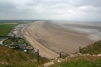
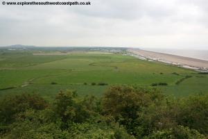
This walk follows the coast as much as possible between Uphill and Brean. The first part of the walk is alongside the river Axe and roads leading to Brean. The second part of the walk is along the beach at Brean north to and over Brean Down offering wonderful views. The walk ends by continuing south on the beach to Brean.
![]()
To reach Uphill, from the M5 motorway exit at junction 21 and take the A370 for Weston-super-Mare. As you approach the town centre take the A3033. At the junction with the A370 turn right. As this turns sharply right turn left onto Uphill Road. Take the first road off this on the right (Old Church Road) and follow this to it's end. At the end of this road turn right onto Uphill Way and follow this to the beach. There is a pay car park on the back of the beach. Be sure to park above the high tide line!
Crosville Motor Services bus routes 5 and 105 between them run regularly between Weston-super-Mare and Uphill. This bus also passes close to Weston-super-Mare rail station which has trains from Bristol and Taunton. For details, see the link below.
![]()
There is a limited choice of accommodation in Uphill. Uphill Manor is a very grand Bed and Breakfast located on the edge of Uphill. Otherwise there is a plentiful choice of accommodation in nearby Weston-super-Mare. Booking.com - Weston-super-Mare provides details and booking for many hotels in Weston-supper-Mare. In addition Visit Weston-super-Mare.com Accommodation is a comprehensive directory of accommodation in Weston. At the other end of the walk in Brean the accommodation is almost entirely caravan sites and camp sites, though the majority require a week booking. Brean Sands Holiday Park is one of the larger parks at Brean.
![]()
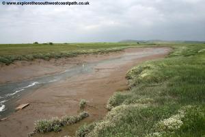
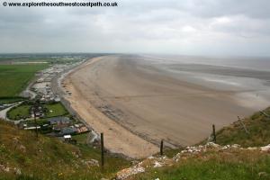
Uphill is at the south end of the beach of Weston-super-Mare and has a good beach although there can be mud at low tide. This walk can be rather frustrating – Uphill is less than half a mile from Brean Down, but because there is not a safe crossing of the river Axe near the shore, most of the mileage of this walk is taken with getting around the River Axe. If you look on a map you might spot a tempting looking footpath over the mouth of the river (on current maps it is shown as two paths, stopping at the river, but older paths showed a path across the river). Do not try it! Although the river may look shallow, especially at low tide, it is surrounded by very deep soft map, you are very likely to get stuck in it. It is not worth the risk.
Therefore, from Uphill it is necessary to head inland, so begin from Links Road by the beach. You have fine views back to the pier and Weston-super-Mare town centre to the right and ahead to Brean Down and the River Axe.
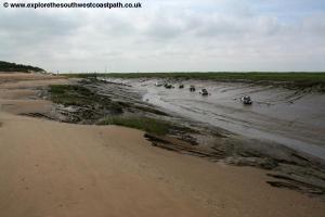
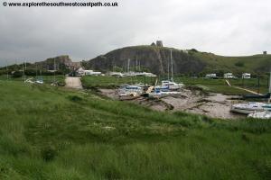
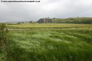
Keep along the back of the beach as you round the golf course and continue past a building on the left and on to a little jetty where there are some boats. Here leave the beach and turn south on the main path right alongside the banks of this muddy river. Continue with the path as it turns left along another little tributary of the river on your right, soon passing a little mariner, with numerous jetty's going out over the mud. Keep to this path to join Links Road where you turn right. Take the first road on the right, into the mariner. Take the right fork off the road past the main fence to the mariner on the left. This forks again and you take the left most fork, with the mariner on your left and then continue on the footpath along it's edge soon passing the lake and a little campsite on the left, whilst the old church can be seen on the cliffs beyond, formed partly by quarrying. The church on the top is the ruined Church of St Nicholas, which was replaced by a new church in 1844 although part of the building is still roofed.
At the south end of the lake the path splits. Go ahead, through the wooden kissing gate, onto the path closest to the river on your right. Follow this path alongside the river until this little tributary joins the main river, where you then turn left with the main path away from the river, heading SEE to the line of trees at the base of the hill. On reaching the hill, turn right on the path along the bottom of the hill, keeping within the field, following the signs for the West Mendip Way, which we have joined. This brings you out into a field. Cross into the next field and head SE, still following the West Mendip Way signs until you reach the main track ahead, a gravelly road. Turn right on this, which very soon forks. At the fork keep ahead heading due south. As this comes to a fork with another track, turn right off this main track and along the path on the embankment beside the river, heading south west.
Follow this river bank path until it re-joins the main track. Head south along the main track which soon splits into two parallel tracks. Take the right (east-most) of the two tracks heading due south. Ignore another track off to the right, which leads into the sewage works.
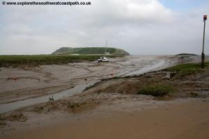
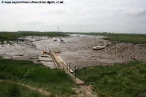
If you are looking at the Ordnance Survey Map at this point you might spot a sluice gate over the River Axe, heading into a caravan park. This was marked as a permissive cycle path on some older copies of the map. It looks like a tempting short-cut, but don't be tempted, there are sturdy high locked gates at either end and public access is not permitted. It is possible the England Coast Path will be routed this way one day but for now, we have to continue further inland to get over the river.
So keep on the main path ahead, as it soon turns a little to the left to head south east. Follow this track for the next mile as it turns again to head south, then east, north and back east again and joins the road, parallel to the railway line. Sadly the next part of the walk is not good. We must follow roads for more than 3 miles and the vast majority of the roads are busy with no pavement and also many bends, which means visibility is poor too. Turn right along the road taking great care as it is busy and has no pavement and you soon pass a small industrial estate on the right and beyond this you cross the River Axe on a bridge. Continue, ignoring further light industrial areas on the right, until the road soon turns sharply to the left, to cross the railway line.
Here you have a choice. There is a footpath off to the right here, to Wick Farm, which provides quite a short cut. It is initially good, along the farm track but when I have tried to follow it, it soon becomes very overgrown, to the point that in summer it is very likely to be impassible. By all means try if you want, but do not be surprised if you have to turn back. Unfortunately the local Council is very poor at maintaining this path. If you make it though on this path, turn right on the road. Otherwise, see the next paragraph.
Assuming the path to Wick Farm was not accessible or you did not try, continue on the road, crossing the railway line on the left. At the junction with Batch Lane off to the left shortly ahead, ignore it and keep ahead on the main road (Rectory Way). Pass Poultry House and farm on the right and then Millfield Cottages 250 metres later. Immediately after the cottages turn right at the junction onto Brean Road. Pass Hope Farm cottages and turn sharp right with the road here. You soon cross back over the railway line. Ignore a road off to the left after you come down from the railway bridge and keep ahead turning right with the road at Yarlington Barn. Follow the road for around 400 metres and you pass Wick Farm on the right, where both routes join.
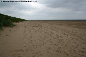
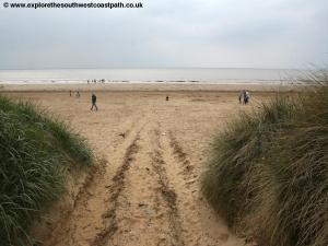
Continue along the road and take great care, as the road twists and turns, can be very busy in the summer (it lacks a pavement). Pass Yellowhayes on the right and ignore the turning off to the left, Red Road, and keep with the road as it turns right, signed Brean. You now follow this road for around two miles, as it twists and turns across this flat landscape and soon passes numerous caravan parks on the left and right. Apart from a small section, there is no pavement, so take great care as visibility on the many corners is poor. On reaching the end of the road with the main road ahead, cross the main road and take the footpath you can see straight ahead going uphill on a very sandy path which leads down to the beach.
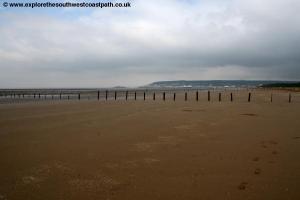
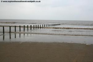
At the beach you have a choice. The recommended route is to continue north along the beach and take the walk over Brean Down, a large hill in an otherwise flat area which offers wonderful views as a result. However you do have to come back the same way so you might choose to skip this bit. Assuming you do want to go this way, on reaching the beach, by a long line of wooden posts (used to mark the parking area of the beach), turn right with the sea on your left.
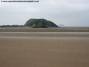
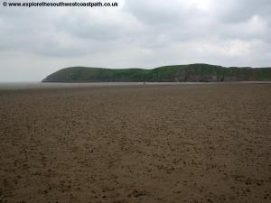
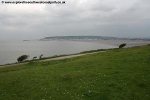
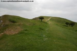
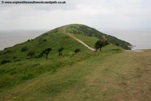
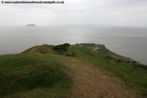
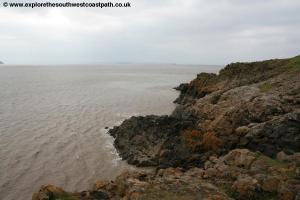
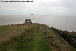
Note that the Severn has a very large tidal range, so the sea is often barely visible if the tide is low! As you near Brean Down ahead, there is some boulders and a little slipway on the right by a house and cafe. Go up this slipway, where there is a National Trust cafe on the left. Keep along the path ahead to reach the road and then turn left. Pass a car park on the right and as the road splits, take the left most fork, passing to the left of another cafe which I believe is also a bird garden. Turn right with the main track to reach the stair case up onto Brean Down. Take this making your way up the fairly steep steps. At the top, turn left along the main path that soon rises to the top of Brean Down. This viewpoint offers wonderful views, over Brean and Berrow to the left, and the sandy beach, out to the Bristol channel where the two islands of Steep Holm and Flat Holm can be seen and the coast of South Wales beyond. Once at the top you can see to the right to Weston-super-Mare.
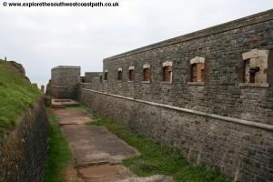
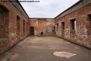
At the far end of the headland the path starts to descend down to Brean Down Fort. This is an old military fort, dating from the 1860s, but with numerous other concrete buildings built during World War II. The fort is accessible to the public for no charge, under the care of the National Trust and there are a few information boards inside about the fort. The fort is accessed via a bridge over a deeper track below. It is an interesting and recommended diversion from the walk. At this bridge you can turn left to explore the fort, or turn right along the wide track, to continue the walk.
As you near the eastern edge of Brean Down, the main track makes a hair-pin bend back down. Here leave the main track and continue ahead on a footpath, still heading due east. This descends, often quite steeply on a narrow path down to some houses. Here you turn sharply right, heading due west and keep ahead on the main track parallel with the downs on your right, passing close to Brean Down Farm on your left. Follow this back to the car park and bird gardens and then back down to the beach.
Continue ahead, back the way you came (due south) along the beach and continue past the line of wooden posts where you joined the beach and keep going for around another mile, until you are level with the rides of Brean Leisure Park you can see on your left. Here turn left and follow the sandy path parallel with a caravan site on the right until you go through a gate and join the road opposite the leisure park, where the walk ends.
![]()
First Bristol, Bath and West route 20 runs up to every 30 minutes back to Uphill. For details see the links below.
![]()
Here are some photos taken on this walk. Click each photo for a larger version and description.
 |
 |
 |
 |
 |
 |
 |
 |
 |
 |
 |
 |
 |
 |
 |
 |
 |
 |
 |
 |
 |
 |
![]()
Ordnance Survey Explorer map 153 (Weston-super-Mare & Bleadon Hill) covers this walk. It is available from local book shops, tourist information centres and online retailers. In addition the links below show the map of this area.
![]()