|
|
 |
|
|
| Distance : 12 miles | Grading : ++ | OS Sheet : N/A |
![]()
This walk takes in the north east and east coast of the island, a coast line of beautiful beaches which is less rugged than most of the rest of the island. This is a walk to take all day over to enjoy the numerous beaches on the walk. The part of the walk from Sampson Harbour to St Peter Port is urban, but still has much of interest.
![]()
The walk begins from Grandes Rocques on the north coast of the island and on the main coast road of the island to the north of Cobo bay. There is a car park and toilets at the beach.
If you are travelling by public transport bus service 3 and 3A terminate at the car park from where the walk starts. This runs from St Peter Port typically twice an hour seven days a week (or as service 3B and 3C on Sunday). The round the island route 7 also serves Grandes Rocques.
![]()
There is a wide variety of accommodation in Guernsey from luxury hotels to self catering cottages to campsites. Visit Guernsey - Accommodation is a comprehensive directory of accommodation on Guernsey, Alderney, Herm and Sark. The Wayside Cheer Hotel is the nearest hotel to the start of the walk.
![]()
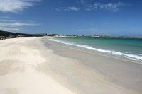
From the car park head to the coast where you have fine views over Saline Bay and Cobo bay to the south. From the car park you can take the path out to the tip of the headland and then continue east, with the sea on your left to the next beach, Port Soif. This is almost a complete circle with only a fairly narrow opening to the sea. It is a good sandy beach with dunes at the back of the beach in the middle and rocks at either end. Continue on the path around the back of the beach and out to the little headland between it and Portinfer, the next beach. Portinfer is another good beach with pebbles at high tide and sand at lower tide.
Continue on the coast path along the back of the beach and at the north end take the path round the little headland passing a small firing range and into the next beach, La Passee, this one being a mostly rocky beach with a few sandy patches. Continue around Pulians Headland and pond, which is used by migrating birds. This brings you round to the next beach, Baie de Pulias, another sandy beach with a small harbour at it's western end. The beach is a mixture of sand, rock and pebbles. Take the road at it's eastern end to join the road briefly around the next beach, Baie de Port Grat. This is a good wide sandy beach backed by rocks and grass. Soon by the slipway you leave the road and continue on the coast path along the back of the beach ro Rousse Headland. This headland has a Martello tower on it, one of may around Guernsey and the path goes around the edge of the headland and round to the next large bay, made up of Le Grand Havre and Ladies Bay. As you reach Le Grand Havre the coast path joins the road which you follow most of the way until near the south end of the beach you can re-join a coast path to the very back of the beach. Vale Church is a prominent landmark ahead.
Turn left with the coast here and continue due north on the footpath adjacent to the minor road heading north along the eastern side of Le Grand Havre. Soon you reach Ladies bay after passing the rocky little islet. This is an excellent sandy beach backed by a golf course and dunes. If the tide is low you can walk along the beach here, otherwise take the path along the edge of the golf course nearest the coast. At the north end of the beach at the slipway tyou rejoin the coast path to go around the headland of Chouet. Here there is another Martello tower and you then come to a pistol firing range. If firing is in progress you will have to go around this on the road, otherwise continue on the coast path as the coast becomes rocky. Sadly the coast here passes the refuse site of the island so can be rather noisy and smelly and the rubbish attracts many sea gulls. Take the footpath adjacent to the refuse site fence around the rocky beach of Creve Couer. Soon you come to another good sadny beach, Baie de la Joanneuse. This is a secluded sandy beach with rocky headlands on either side.Continue ahead to the next beach, Pembroke Bay.
This is a glorious sandy beach backed for much of it's length by a concrete wall, a relic from World War II.This is an excellent beach with calm shallow waters, making the most of it's north easterly outlook. The martello tower in the centre of the beach has been painted blue and turned into a cafe and you can enjoy views from the top of it's tower. The coast path goes around the back of the beach just behind the sea wall or you can walk along the beach. The eastern end of the beach is known as L'Ancresse Bay and has another martello tower.
Follow the coast past a rocky beach to Fort le Marchant where there is a rocky beach and a rifle range as well as another old martello tower. The fort can be explored when the firing range is not in use. Ahead is the rocky Fontenelle Bay and the coast path goes along the back of this. As you reach the eastern end of this beach you come to Fort Doyle, another old fort which can also be explored. Just beyond this the walk begins to become more urban as you reach Beaucette Marina. There is no access over the entrance to the marina so here you join the road behind the marina and take the most coastal of the roads at all time, a green lane. As the road splits take the left most fork to briefly rejoin the coast at Miellette. Here to the right you can see the small Houmet Paradis island just off the coast. Continue on the most coastal green lane as it heads inland and at the junction turn left and then take the next road on the left to head back out to the coast at Petils Bay. This is a rocky beach with some sand at low tide. Turn right with the green lane and continue ahead as there is a footpath beyond. Sark and Herm are now clearly visible off the coast.
Soon you reach Bordeaux Harbour and follow the road around the back of this harbour and then turn left on the main road, Castle Road. This road goes past the back of another sand and shingle beach and soon passes Vale castle on the right. This is a large castle which you are free to explore. Continue along the road past some industry as we approach St Sampson Harbour one of two main ports on the island, the other being St Peter Port. Soon the outlook is more pleasant with a large harbour filled with small boats. Round the harbour and keep to the road along the back, where there are numerous shops. Continue round the south side of the harbour and continue on the main road. This part of the walk is not especially pleasant, going through an industrial area and soon you come to the next beach, Belle Grever Bay. This is a sand and shingle beach but rather dominated by the now very busy road along it's back. Soon you come to a little harbour and as you go around this harbour wall suddenly you are in St Peter Port. Follow the main road along the back of the harbour to the large roundabout. Continue south aong the promenade behind the harbour passing the information centre. The walk ends at the south end of the harbour at the bus station.
![]()
From St Peter Port bus station bus routes 3 and 3A will take you back to Grandes Rocques. On Sundays this is route 3B or 3C. In addition service 7 also serves Grandes Rocques, but it does take longer on this bus.
![]()
Here are some photos of the walk. Click each photo for a larger verson.
 |
 |
 |
 |
 |
 |
 |
 |
 |
 |
 |
 |
 |
 |
 |
 |
 |
 |
 |
 |
 |
 |
 |
 |
 |
 |
 |
 |
 |
 |
 |
 |
 |
 |
 |
 |
 |
 |
 |
 |
 |
 |
 |
 |
 |
 |
 |
 |
 |
 |
 |
 |
 |
 |
 |
 |
 |
 |
 |
 |
 |
 |
 |
 |
 |
 |
 |
 |
 |
|
![]()
The UK Ordnance Survey do not provide maps of the Channel Islands. A good quality map is however available on the island from the main bookshops in the town and the visitor information centre. An alternative is the free maps available at the airport and ferry terminal and the information centre which show the main roads, green lanes and footpaths.
![]()