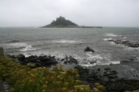
The South Cornwall section of the path passes through several pretty fishing villages. It also takes in the spectacular and remote Lizard peninsula which has some excellent beaches. To the west, is St Michael's Mount at Marazion.
 |
 |
|
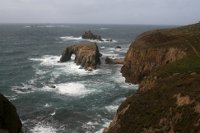
This is a spectacular walk in the far south west of Cornwall, taking in the famous Lands End, the most south-westerly point of mainland Britain. The walk begins at Cape Cornwall and then follows the coast south soon coming to wonderful Whitesand Bay and Sennen Cove, at it's southern end. From here it's a short distance to Lands End and onwards to beautiful Nanjizal. Continuing round the coast we pass Porth Loe, Porthgwarra and Porth Chapel to finish at Porthcurno, home of the Minack Theatre and the first trans-atlantic telephone cables.
|
|
 |
 |
|
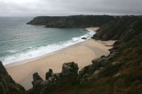
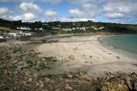
This is a wonderful walk beginning in Penzance and heading through neighbouring Newlyn along roads. From Newlyn we soon reach beautiful Mousehole, a classic Cornish fishing village. From here the coast becomes a bit more wild as it passes Lamorna Cove and the lighthouse just to its west. The walk continues via St Loy’s Cove and Penberth and ends at wonderful Porthcurno with its magnificent sandy beach and the Minack Theatre perched on the cliffs overlooking the beach.
|
|
 |
 |
|
This walk begins from the attractive town of Penzance in the far south west of Cornwall. The walk is initially easy, following the tarmac path along the sweep of Mounts Bay, passing the famous St Michael's mount. From Marazion we briefly follow roads but soon rejoin the cliff top path to Perranuthnoe and the find sandy beach of Perran Sands. Rounding Cudden point we continue to the second sandy beach, Praa Sands and on around Trewavas Head to the attractive town of Porthleven. |
|
 |
 |
|
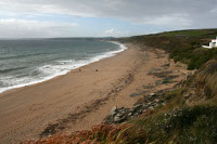
This walk begins from the southern tip of the beautiful Lizard Peninsula and heads west along this rugged coast taking in Kynance Cove and Mullion Cove. West from here the coast becomes less rugged and with more beaches, including lovely Poldhu Cove and ending at the large expanse of Porthleven Sands, which runs for several miles.
|
|
 |
 |
|
This walk takes in the most southerly point of main land Cornwall and England, Lizard Point and follows the eastern coast of the Lizard Peninsula. This east facing coast is more sheltered and offers a mixture of rocky headlands and sandy beaches, many of which are very quiet. There are however quite a few steep ascents and descents.
|
|
 |
 |
|
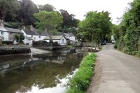
This walk is along the more gentle south coast of Cornwall. It begins with a walk alongside the beautiful Helford River to the pretty and remote village of St Anthony in Meneage. From here you can cross Gillan Creek either by walking around it at high tide or via stepping stones at low tide. There is sometimes a ferry available here at high tide. From here the walk heads east to Nare Point to re-join the sea and heads south to Porthallow along the coast. South from here most of the next couple of miles of the path is away from the coast (and some on roads) until the coast is rejoined south of Rosenithon where the walk continues along the coast to Coverack, passing a couple of quarries. Note that although flat the last part of this walk can still be tough as the coast path is rough and rocky with numerous boggy areas.
|
|
 |
 |
|
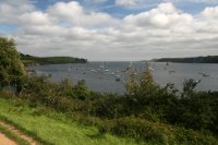
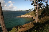
Unusually for the South West Coast Path, the first few miles of this walk are urban passing around the maritime town of Falmouth with its castle, beaches and harbour. Later the walk becomes more rural heading out onto the Lizard Peninsula passing through the small villages of Maenporth, Mawnan and Durgan to end at Helford Passage on the north bank of the river Helford.
|
|
 |
 |
|
This walk begins at Place on the Roseland Peninsula just across from Falmouth. The walk is initially a quiet and fairly gentle walk along cliff tops around the estuary. After passing through Portscatho the walk becomes a little harder with the coast more undulating but there are also some good sandy beaches on this part of the walk. The walk ends at the small but charming fishing village of Portloe, with numerous cottages clustered around a narrow harbour.
|
|
 |
 |
|
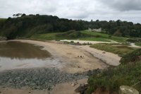
This walk links two pretty villages, Portloe and Mevagissey. The walk takes in the sandy beach at Portholland and Porthlune Cove and then becomes more rugged to head out to Dodman Point. Continuing round this headland the walk continues through Gorran Haven, around Chapel Point and on to Portmellon and Mevagissey.
|
|
 |
 |
|
This is a walk of two halves. The first part is a fairly gentle walk past the sheltered beaches of Par and St. Austell, including pretty Charlestown. Once we leave St Austell behind the walk becomes much tougher, taking the National Trust owned Black Head and the village of Pentewan, with many climbs to cliff tops and descents back to sea level on the way. The walk ends in the pretty fishing village of Mevagissey.
|
|
 |
 |
|
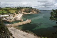
This walk begins in Par a town known for it's heavy industry but soon we head out over Par Sands and around the eastern edge of the sheltered St Austell Bay to the pretty village of Polkerris and on to Gribbin Head. Once round the head the walk heads east to end at the pretty riverside town of Fowey.
|
|
 |
 |
|
This walk is one of the most beautiful on the whole coast path, taking in some stunning scenery but it is also one of the toughest section, especially between Polruan and Polperro. However the rewards are worth the effort with some stunning views and near deserted sandy beaches. Polperro is also a real treat and not to be missed. If the walk is too long it can easily be split at Polperro. |
|
 |
 |
|
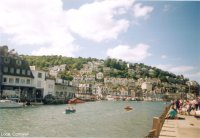
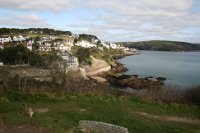
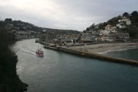
This walk starts from the popular resort town and fishing port of Looe situated at the mouth of the river and split into East and West Looe. From here we head east along roads and tracks to Millendreath. Beyond Millendreath the walk is mostly rural with fine views. The walk passes through the villages of Seaton and Downderry where road walking is needed at high tide before we return to good quality cliff top paths for the rest of the way to Portwrinkle.
|
|
 |
 |
|
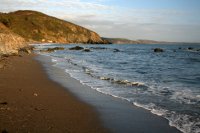
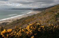
The first part of the walk takes in the rocky and wooded cliff tops to the east of Rame Head including the pretty villages of Kingsand and Cawsand. Once round Rame Head the walk follows the beautiful Whitsands Bay, a lovely bay with sandy beaches backed by gorse covered cliffs. Note that this walk goes through a military firing range (there is a diversion when the range is in use) and there is some road walking at Whitsand Bay. |
|