 |
|
|
| Distance : 14 miles | Grading : ++++ | OS Sheet : OL9 |
This walk takes in the highest sea cliff in England, Great Hangman, at 318 meters high. The walk begins from the beautiful town of Lynmouth in the heart of Exmoor and climbs steeply to it's sister at the top of the cliff, Lynton. From here you head west through the spectacular Valley of Rocks and on to Lee Bay and Lee Abbey. The walk continues west past the beautiful wooded Woody Bay and on via lovely heathland to Great Hangman and down to Combe Martin.
The walk begins from Lynmouth. If you are travelling by car, Lynmouth is along the A39 road that runs along the north edge of Exmoor. It is worth noting that there are very steep hills into Lynmouth, whether you come from the west or the east and great care needs to be taken particularly in bad weather. The road, despite being an A-class road has many tight bends, steep hills and some small single track sections. There are several car parks in Lynmouth (pay and display) or you may prefer to park in Lynton and take the cliff railway down to Lynmouth. Due to the limited direct public transport between Combe Martin and Lynmouth (see below) you may prefer instead to park in Combe Martin and travel by bus into Lynmouth so you can walk back to your car in your own time.
If you are travelling by public transport, bus services 309 and 310 provide a broadly hourly service to Lynton and Lynmouth from Barnstaple. There is a railway station at Barnstaple with train services to Exeter from where there are connections into long-distance trains. In addition bus 300 runs a few times daily to Ilfracombe via Combe Martin. For details please see the link below.
There is a good choice of hotels and bed and breakfast accommodation in Lynton and Lynmouth. Some are right next to the coast path as you head west out of Lynton. For details see the links below or call the tourist information centre on 0845 6603232. There is also a good choice of camping and self catering accommodation available close by.
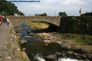
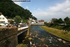
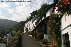
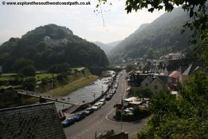
Lynmouth (and it's neighbor Lynton at the top of the cliffs) is a really beautiful town known as Devon's little Switzerland due to the very hilly nature of the surrounding countryside. This makes for a stunning walk but also a fairly tough and long walk. The town nestles in the Lyn valley with the pretty river flowing through the middle of the town. However it was not always so peaceful, with the river bursting it's banks and seriously damaging the village in 1952, when many of the buildings were destroyed or seriously damaged, with many losing their lives in the floods.
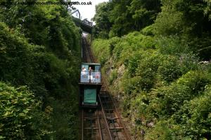
Beginning from the little pier beside the harbour on the west side of the river head along the road and fork right up the hill past the buildings on the right. Turn to the right and follow the tarmac path as it zig-zags it's way up the cliff crossing the track of the Lynton and Lynmouth cliff railway several times. This unique railway is water powered as the trains are connected together. The train at the top has a tank underneath the train filled with water, causing it to be heavier and so travel down the track, pulling the other train to the top. The water is then emptied from the tank at the bottom and the top filled to repeat the process. As you reach the top you will pass the top station.
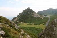
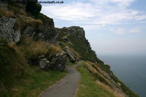
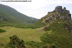
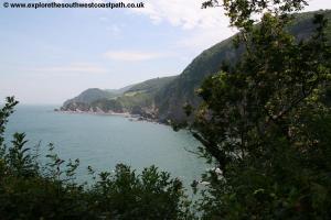
Continue on the road here past a number of hotels to the left with fine views down over the bay below. Soon you pass the last of the hotels and the path narrows, but is still tarmac. The cliffs to the right are now almost a sheer drop, yet you will often see mountain goats climbing around these very steep slopes. Rounding the cliffs into Wringcliff Bay the path descends down to the road, although the steep rock, Castle Rock ahead can be climbed with care, offering good views. This area is known as the Valley of Rocks, being unusual to have such a steep valley immediately adjacent to the coast. On coming down to the road, where there is a little roundabout, you take the road straight ahead.
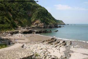
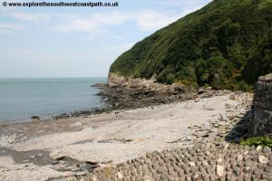
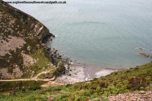
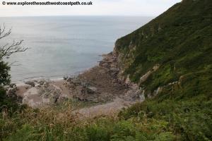
The road ahead is a toll road, as it is a private road and so there is very little traffic along it most of the time. Soon you pass Lee Abbey on the right, a religious centre. Continuing along the road it descends down to a car park and cottage and the toll is usually collected here. To the right is a car park and toilets. To the right is Lee Bay, one of two identically named places on the North Devon Coast. The coast path doesn't actually go down to the beach, but it's a worthwhile diversion. The beach is a rocky and stony beach with a stream flowing across it and tall cliffs on either side and is a beautiful and secluded spot.
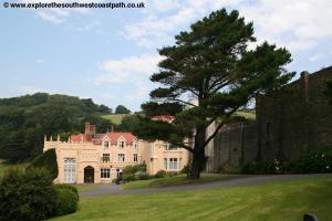
Returning to the coast path, continue along the road ahead as you climb out of the bay. You come to a junction where the coast path is signed two ways, either along the road or an alternative route to the right. The alternative route briefly follows field edge paths along the coast and offers good views, but is a slightly longer distance. Whichever way you choose you soon end up back on the road and you follow it close to the Woody Bay Hotel, an isolated hotel. Just after the hotel take the path on the right following a track through the woodland as you descend. The coast path again misses out going down to Woody Bay, but if you choose to do so, follow the track off to the right, as it doubles back through the woodland and descends down to the beach. Like Lee Bay before this is another isolated and rocky beach but one that is very peaceful and offers wonderful views.
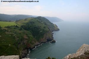
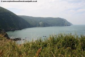
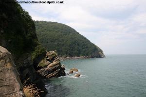
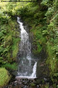
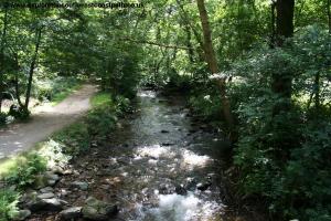
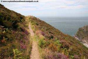
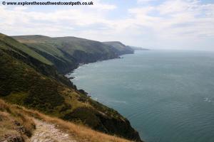
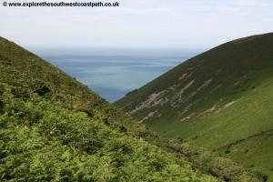
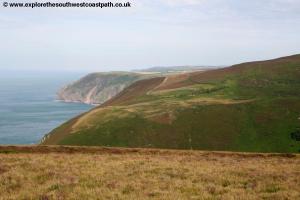
Return to the coast path west and follow the surfaced track westwards. As the surfaced track (really a road) comes to a tight bend go straight on to return to a footpath through the woodland. The path then turns west to follow the coast and crosses the little stream of Hollow Brook, leading from the little village of Martinhoe a little over a half mile inland. Beyond you come to a lovely waterfall and continue west above the cliffs known as The Cow and Calf. The path ahead is still very rocky and the coast is lined with heather which is beautiful in the high summer months when in flower. Continue along the coast path west to Highveer Point, where you can enjoy fine views of the coast ahead and the steep valley of Heddons Mouth below. Due to the very steep gradient you have to head around a half mile inland to cross the stream.
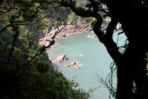
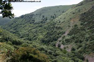
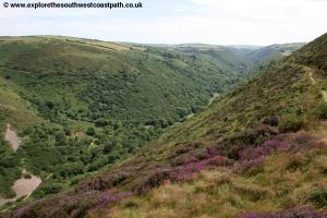
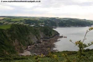
Take the path along the top of the cliffs heading south and gradually descending. This is a beautiful wooded valley with another little fast-flowing stream at the bottom that has cut this steep valley. On descending down you reach a bridge over the stream which you take, but briefly continue south beside the stream before turning right and taking a path that zig-zags quite steeply back up to the cliff top and then turns back north. It is very well signed and once you reach the top it again offers lovely views of the valley. The wide track you joined at the bottom of the valley can be joined to come down to the stony beach at the end, Heddons Mouth beach which again, like other beaches along the walk, the official route of the coast path does not take in.
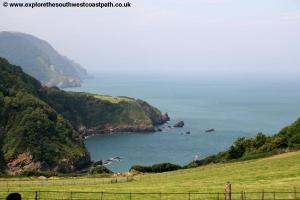
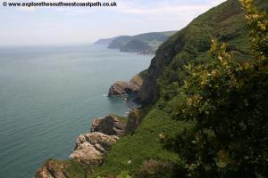
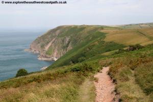
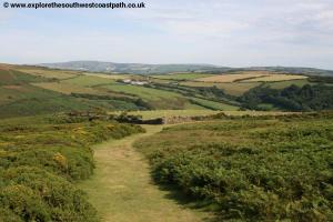
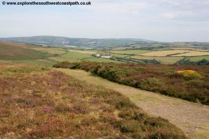
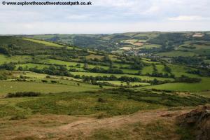
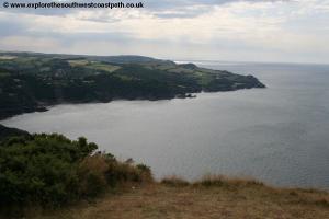
Once up to the top of the cliffs you have lovely views of the path you have just taken on the other side of the valley. The path continues west along the heather-lined cliffs. The path is very spectacular, with rocky outcrops to the left and a steep drop to the right down to the sea level. As you round the path you have lovely views of the wide bay, Elwill Bay and the coast ahead. The path turns briefly south and then joins a path along the edge of various fields. It continues like this west, passing close to the village of Trentishoe. After around 2 miles or so of the path beside fields you continue ahead onto the beautiful Trentishoe Down.
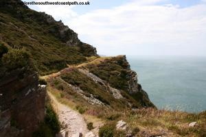
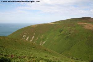
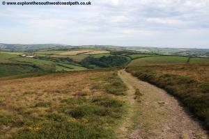
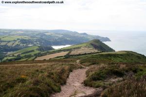
The path follows close to the top of the down and is actually a little back from the sea edge. Ahead you can see the numerous hills, including the Great Hangman, the highest point on the whole coast path. Continue west along this obvious rocky and gravel path. After around a mile the path enters a field which you go straight across and into a second field where just before the boundary you turn to head south, as the path now has to divert a little inland around another valley, Sherrycombe. Keep the field edge to your right and at the southern edge of the field you turn right to head west again. Shortly after you turn ignore the footpath going off to the left and continue straight on along the edge of another field keeping the wall to your left. The path again forks ahead, take the right most fork as it turns to head west once more. The path now descends towards the stream which you cross via a footbridge and then begin to climb back up the other side.
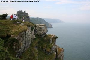
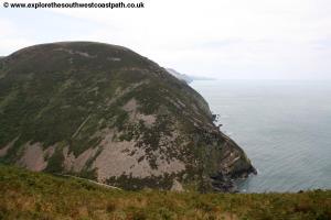
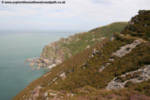
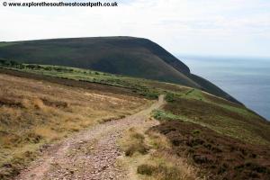
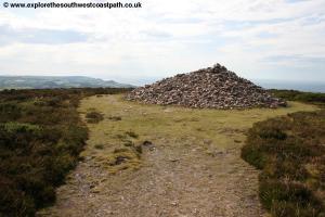
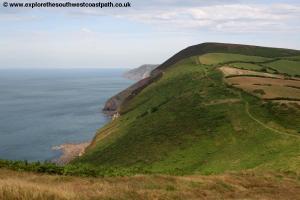
The path then turns sharply to the right and begins to turn back towards the coast and continues to climb. The path joins the edge of a field on the left and you keep to the coast side of the field boundary. As you come to the corner of the field and the field boundary turns south keep going straight on along the obvious path as you begin to climb to the summit of Great Hangman. A cairn marks the summit of the cliff which is the highest point on the coast path at more than 1000ft high. There are, as you would expect, excellent views all around both to the sea and inland to the rolling hills of Exmoor.
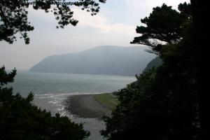
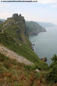
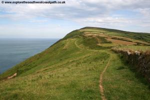
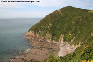
Leaving the cairn you continue west as the path now begins it's descent into Combe Martin. Soon you have a field boundary on your left once more and walk on the coast side of this. The path goes slightly south of the tip of Little Hangman although there is an easy path to the top of the summit if you would like to enjoy the view from it. Keep going west with the field walls close by to your left. Soon you are rounding the back of Wild Pear beach below. This is a lovely beach though with very difficult access down. It is rocky at high tide but has some sand at low tide.
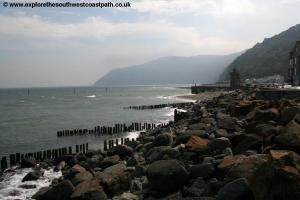
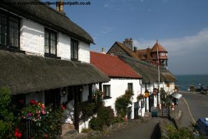
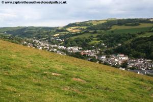
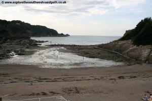
The path now returns right to the cliff edge as you continue west pass a little wooden shelter on the cliff top. Just beyond this the official route of the coast path turns left, but a better route is to turn right keeping to the cliff top path then descend the grassy area beyond down to the car park on the cliff top. You round the back of the beach down to a larger car park and the main beach of Combe Martin. The village is in a small valley and so most of it stretches inland along one long street, rumored to be the longest village street in England. The beach and rock pools here are worth exploring if you have the time and energy whilst a little inland along the road you will come to the Pack O'Cards pub, that originally had 52 windows, 13 rooms and 4 floors, although it has been modified over the years with some windows filled in. The village has all the amenities you might expect including food shops, pubs and cafes.
To return to Lynmouth bus service 300 runs several times daily during the summer but is not frequent. If this is not an option there are frequent buses back to Barnstaple from where you can change onto a more frequent bus service back to Lynmouth, although services are limited on Sundays. For details, see the link below.
Here are some photos of the walk. Click each picture for a larger version and description.
 |
 |
 |
 |
 |
 |
 |
 |
 |
 |
 |
 |
 |
 |
 |
 |
 |
 |
 |
 |
 |
 |
 |
 |
 |
 |
 |
 |
 |
 |
 |
 |
 |
 |
 |
 |
 |
 |
 |
 |
 |
 |
 |
 |
 |
 |
 |
 |
 |
 |
 |
 |
Ordnance Survey Explorer map OL9 (Exmoor) covers this area of the coast path and is available from most book shops nationwide and many local shops as well as the Lynton tourist information centre.
Streetmap is a web site which provides maps of the UK, including around Lynton, Lynmouth and Combe Martin. The links below will be of most use to the coast path from Lynmouth to Combe Martin. These maps join to provide the complete coast path between the two points.