|
|
 |
|
|
| < Pill to Portishead | Worle to Uphill > |
| Distance : 16 miles | Grading : ++ | OS Sheet : 154 & 153 |
![]()
This walk follows (as far as possible) the coast from Worle to Portishead. As there is no footpath along the coast from Worle and Sand Bay the first few miles of the walk are along roads via the villages of Hewish and Kingston Seymour but soon reaching the coast just south of Clevedon, offering fine views back to Sand Bay and to the coast of Wales on the other side of the Severn Estuary. From Clevedon to Portishead there is a good coast path along the cliff tops that we follow for the rest of the walk.
![]()
This walk begins from Worle railway station which is easily reached from the M5 motorway and has a large car park. From the M5 motorway exit at junction 21 and join the A370 south west to Weston-super-Mare. Very soon after you join the A370 take the slip road off onto the B3440. After going over the railway line you come to a large junction, keep left here coming to a roundabout at an out-of-town shopping centre. Go straight on here and then turn left at the next roundabout. At the small roundabout go straight on to come to the car park at Worle station (pay and display).
If you are coming by public transport Worle station has two trains per hour Monday -Saturday between Weston-super-Mare and Bristol. Many of these trains continue south to Taunton and north to Newport and Cardiff. On Sundays the service runs roughly hourly. All trains to Worle are operated by Great Western Railway. In addition bus route X1, operated by First Bristol, Bath and West runs to Worle from Bristol and Weston-super-Mare every 15 minutes Monday – Saturday and every 30 minutes on Sundays.
![]()
There is no accommodation in Worle itself, but it is very close to Weston-super-Mare which has an extensive range of accommodation from guest houses and caravan sites to large hotels. Booking.com - Weston-super-Mare provides details and bookings for many hotels in Weston-super-Mare. In addition Visit Weston-super-Mare.com Accommodation is a comprehensive directory of accommodation in Weston. Travelodge have a hotel at Portishead at the end of the walk and Permier Inn have a hotel in both Weston-super-Mare and Portishead. There is also a lot of accommodation available in Clevedon on the route.
![]()
Sadly there is little public access to the coast between Sand Bay (north of Western-super-Mare) and Clevedon and as a result the first part of this walk has to follow mostly on roads rather than footpaths and often some distance in land. The walk begins from Worle station (sometimes also referred to as Worle Parkway). There is a large free car park at Worle station. The first part of the walk may be a little different, since it goes through a modern housing development that is still expanding and therefore new streets are being added! From the railway station follow the station access road straight ahead to a roundabout, which you cross and go straight on. This comes to a much larger roundabout, part of the B3440. Turn right here passing the Summerhouse pub on the right. This comes to another large roundabout with a large out-of-town shopping centre visible ahead. Go straight on here passing a mobile home park on the right. When safe to do so, cross to the other side of the road and at the large junction ahead you need to turn left, heading due north passing the Homebase on the left. Take the first road on the right, Pastures Avenue now leaving the main roads behind. At the roundabout turn right, still on Pastures Avenue. Follow this passing houses on the left and soon the road turns sharply to the left, soon passing the modern school on the left. Keep with the road as it turns left again to head north, with the school on the left. At the junction ahead turn right into Pastures Avenue. Ignore the first road on the left, The Badgers and take the second, Brimbleworth Lane. Then take the first road on the right, The Badgers (again). As this comes to a junction ahead turn right along Riverside Close. At the end ahead, take the tarmac footpath onto Bourton Lane, at last leaving this modern development and heading out into countryside.
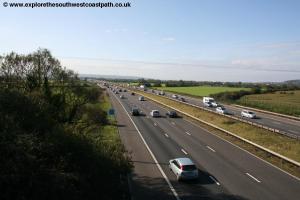
This part of Somerset is very flat and criss-crossed by numerous rivers and drainage channels which means there are few footpaths, so we have to walk on roads for much of the way. Therefore keep along Bourton Lane which doesn't have much traffic along it (but there isn't a pavement, so take care). Keep to this road as it twists and turns around the various drainage channel, with the M5 close by on the right. After around a mile of following the bends along the road you pass a farm on the left, with some old asbestos barns. Keep to the road passing the farm on the left until just past the farm it comes to a T-junction. Turn right, signed for West Hewish. Follow this for around 400 metres until you come to another T-junction. Here turn right along Wick Lane, taking care as this road is much busier. The road soon climbs to cross the M5 motorway and then descends back down the other side.
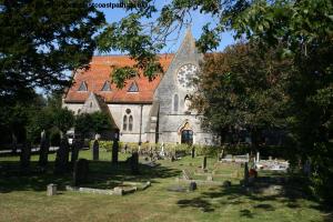
Keep along this road for around a mile as it crosses the railway lane and turns to the left, now heading east. On reaching the main A370 turn left and follow the main road (which does have a pavement). This is the village of Hewish, although it is more a hamlet being mainly just along this road. Soon you pass over the Oldbridge River and then pass the school and attractive church on the left.
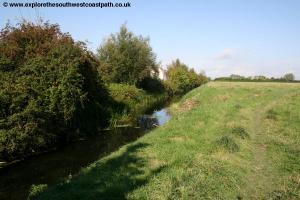
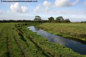
Soon you pass a less attractive caravan and motor home dealer and a pub beyond. Take the road immediately next to the pub, passing the pub on the left and crossing the level crossing. Follow this road into East Hewish, which soon narrows to a track, where there are various signs about a storage company. The road soon turns right to head briefly east and here there is a road off to the right or the main track, which turns sharply left, to almost double back on itself. Take the latter route, the main track that doubles back now heading west. Shortly on the right hand side, after passing the field edge hedge on the right, take the signed footpath into a field. From here the sign age is poor and the path is not obvious on the ground either, which makes navigation tricky. The correct route here is to head NW keeping the field edge on your right and soon getting to a gate which you take into the next field. Here you head NW and soon meet the raised banks of the River Yeo, which we need to cross.
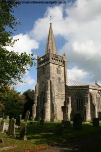
Keep to the path with the pleasant river on your right as it turns to the right heading due north, keeping to the right of the little group of trees ahead. After passing the trees on your left keep straight ahead parallel to the river heading to the gate and weir structure (Philip's Bridge). Cross the river via the metal bridge. The Ordnance Survey map shows the path ahead on both sides of the M5 motorway, but sadly there is no way to cross the motorway here (there is just a large pipe going under the motorway). So once over the bridge turn right and cross the drainage channel via the little footbridge and then turn right and follow the right hand edge of the field heading NE with the drainage channel on your left and the M5 on your left. Keep to the right hand edge of the field beside the drainage channel through the next field and then onto a little orchard, which you pass through, still keeping on the right of the field. This comes to a building ahead where you then turn left on the wide farm track, heading NW. Sadly this path can get very wet and muddy and there are a couple of gates to cross through. Soon the track rises up to a bridge over the M5. Keep ahead here, ignoring the track off to the right and cross the M5 via this bridge. Descend down the other side from the bridge and when the track forks, take the right most fork heading NNW. Ignore another track off to the right and just beyond it another on the left and keep ahead soon passing another large farm on your left (Yewtree Farm). Here the track becomes a public road and you follow it to a T-junction where you turn right to enter the centre of the village of Kingston Seymour. This has an attractive church on pond on the right hand side and you keep along this until you come to the main village green and memorial.
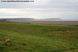
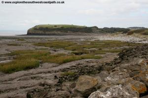
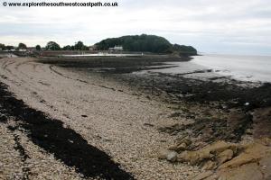
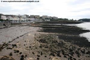
Turn left here, with the memorial on your right and ignore the road off to the left and right and pass the bus shelter on your right. Ignore the road to the right and keep with the road, Back Lane, with a little fence on the right, heading due north. Soon you leave the village and continue north, ignoring Bullocks Lane on the right, which leads to Bullocks Farm. Ignore the second road on the right and keep straight ahead. Soon the road turns sharply left, with a track off to the right. Ignore the track and keep to the road now heading west, passing Elmleigh Farm on the left. Continue on this road for around 500 metres until you have the road New Cut Bow on the right (incorrectly marked on the Ordnance Survey map as Back Lane), now heading north. Pass Poplar Farm on the right and ignore the path leading off to Seawall Farm on the left but keep with the road as it becomes Lower Strode Road. This soon turns sharply right and then sharply left and passes Lower Farm on the right. Just after this the road turns sharply right and there is a track off to the left. Here turn left, leaving the road and heading west. You now follow this track as it heads west to reach the sea wall south of Clevedon. Here you can finally enjoy fine views of the coast, with the coast of South Wales clearly visible across the estuary and the headland of Middle Hope to the left, near Sand Bay.
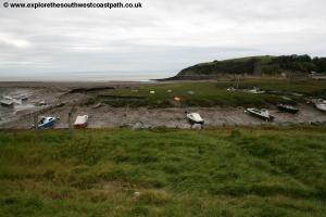
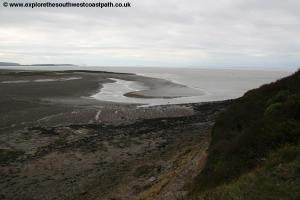
Turn right here and follow the lower or upper path adjacent to the estuary. The Severn estuary has a huge tidal range which means unless it is high tide you will likely have wide mud flats on the left. Keep with the main track as it turns right, briefly away from the coast with part of a golf course on the right and keep on the track as it crosses the artificial channel of Blind Yeo. Now follow the wide surfaced path behind this little muddy harbour, backed with boats.
At the north end of this bay a road goes off to the right, but the better route is to take the steep path and steps ahead climbing up to the headland of Wain's Hill. At the top it gets very steep and is quite awkward but once at the top there are seats where you can enjoy the fine views south and to the north to Clevedon as well as over the estuary to Wales with the two islands (Flat Holme and Steep Holme) in the Bristol channel ahead. Follow the good quality path around this lovely hill enjoying the fine views and soon descend down to the boating lake.
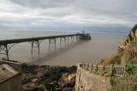
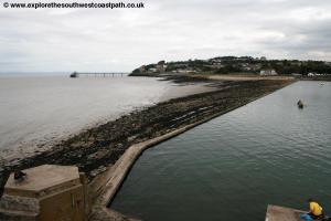
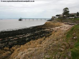
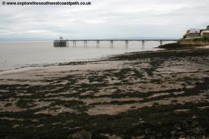
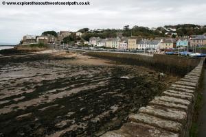
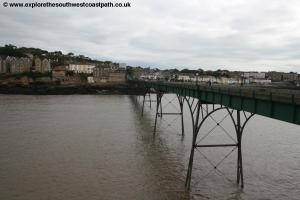
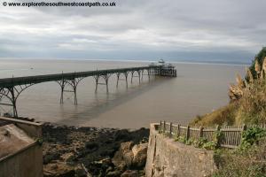
Follow the surfaced path behind the boating lake and then along the back of the beach. Continue on the main promenade path along the back of the beach and pass a grassy area with a bandstand to another little beach with Clevedon Pier ahead. The pier was constructed in 1867 and opened in 1869 and is largely constructed from the steel from old railway lines. The pier had numerous uses but it's principal one was for the steamers that once criss-crossed the Severn linking towns such as Clevedon with Cardiff and Newport and further west Ilfracombe with Swansea, all of which have now ceased. However come the 1970s and the pier structure had weakened to the point that it collapsed during load testing. After a period of fund raising and various grants (including half a million from English Heritage) the pier was restored and re-opened in 1989 although the pier head was not fully restored until 1998. The structure is now Grade I listed and a particularly elegant pier. You can visit the pier via the toll house (where you still have to pay a toll, currently £1.50 to walk along the pier).
From the Pier you follow the road that now climbs up. As the road splits ahead keep to the main route of the road to the right. As this reaches a junction with Marine Hill turn left on the surfaced footpath back to the coast. This surfaced path goes along behind the back gardens of the properties that line the coast here and offers fine coastal views. Soon you reach the beach at Ladye Point.
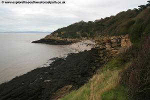
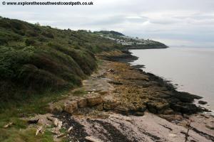
You now pass another few houses on the right and soon leave Clevedon. You now follow the undulating coastal path along the cliff tops for around a mile, soon passing the signal station up to the right. Soon you pass the mobile home and caravan park on the right at Walton Bay, another little beach.
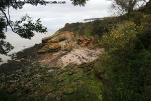
Continue on the cliff top path around this to another little beach, Charlcombe Bay. Like all beaches along the coast there is a lot of mud when the tide goes out. Soon you have a large fence and some sort of military looking establishment on the right, with high fences on your right preventing entry into the site. Continue ahead now with houses and gardens on your left, as we have now entered Portishead.
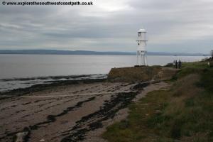
Continue passing a very grand building on the hill up to the right until you reach the little lighthouse (that looks like it's on stilts) at Black Nore Point. Here leave the coast and turn right on the track that crosses the private road around the estate of the large house and keep to the path going north as it climbs up and soon comes to the road. The large building is the old Nautical College but is now converted to flats. On reaching the road turn right until you come to the bus stop where the walk ends.
![]()
To get back to the start take bus services X3 or X4 to the centre of Portishead. These routes run up to 4 times an hour between them, but are reduced in frequency on Sundays. From Portishead, bus route X5 runs hourly Monday – Saturday back to Worle and once every 2 hours on Sundays. All these bus routes are operated by First Bristol, Bath and West. Trains between Bristol, Weston-super-Mare and Worle are operated by Great Western Railway.
![]()
Here are some photos taken on this walk. Click each photo for a larger version and description.
 |
 |
 |
 |
 |
 |
 |
 |
 |
 |
 |
 |
 |
 |
 |
 |
 |
 |
 |
 |
 |
 |
![]()
Ordnance Survey Explorer maps 154 (Bristol West & Portishead) and 153 (Weston-super-Mare & Bleadon Hill) cover this walk. The maps are available from local book shops, tourist information centres and online retailers. In addition the links below show the map of this area.
![]()