|
|
 |
|
|
| < Portloe to Mevagissey | Par to Fowey > |
| Distance : 11 miles | Grading : +++++ | OS Sheet : 105 & 107 |
![]()
This is a walk of two halves. The first part is a fairly gentle walk past the sheltered beaches of Par and St. Austell, including pretty Charlestown. Once we leave St Austell behind the walk becomes much tougher, taking the National Trust owned Black Head and the village of Pentewan, with many climbs to cliff tops and descents back to sea level on the way. The walk ends in the pretty fishing village of Mevagissey.
![]()
Par is on the A3082 road that goes between Fowey and St. Austell. From the A38 from Plymouth, take the A390 just after Liskeard, passing through Lostwithiel on the way. In St Blazey turn left onto the A3082 into Par. If you are returning by train from St Austell there is a car park at Par Station you can use. Otherwise park at Par Beach (which adds around a mile to the walk) or there is a car park near the Chinal Clay works on the A3082 (Par Moor Road) just west of the harbour.
If you are coming by public transport Par has a railway station. Most trains on the main line through Cornwall from Plymouth in the east to Penzance in the west stop at Par and run via Liskeard, Bodmin Parkway, St Austell, Truro and Penzance with many trains stopping at other stations (such as Redruth) as well. The trains roughly hourly, with many continuing on to Exeter and then to either the Midlands and North (via Bristol) or to London Paddington. In addition there are also local trains to Par from Newquay on the north coast. These run several times a day, but there is no Sunday service on the line to Newquay in the winter. As well as trains there are also buses to St Blazey, St Austell and Fowey. For details, see the links below.
![]()
Par is a relatively small place although it does have some accommodation there is a better choice in nearby St Austell. Par Hotels and Lodgings provides a directory of accommodation in Par. The Pier House Hotel has a lovely setting overlooking Charlestown harbour and is passed on this walk. The Carlyon Bay Hotel is another hotel passed on this walk. If you prefer something cheaper Permier Inn have a hotel in St Austell. Finally if you prefer camping or caravan accommodation, East Crinnis Holiday Park is a short walk from Carlyon Bay.
![]()
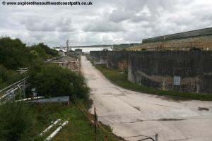
This walk is best done in this direction for the simple reason that the coast gets more spectacular the more the walk progresses. In addition Par harbour is not exactly scenic so it's nice to get this out of the way at the start of the walk rather than an anti-climax at the end. From Par railway station follow the station access road and at the end turn right into Eastcliffe Road. A few metres down the road look for the stile in the fence to the right which you take to enter the recreation ground. Head diagonally across the football pitch towards the trees and cross the bridge that leads over a little stream. Once over the bridge turn left on the tarmac cycle and footpath and follow this until it joins the main road, Moorland Road. Turn right along the road and after passing about half a dozen houses on your left take the signed footpath between the house. This follows a tarmac path between houses to emerge onto Par Green. Turn right on this main road and follow it, soon passing under the railway line. Continue passing the rather quaint level crossing. This is still used but only for freight trains accessing Par Harbour, which don't run regularly. On reaching the junction just past the level crossing turn left on the main road, the A3082. Continue along the road parallel to the railway line to the left and soon passing under the main Plymouth to Penzance line. Soon you pass the entrance to the vast China Clay works on the left.
This area of Cornwall is still quite industrial as the China Clay industry is very active with much of the clay extracted locally and shipped out via Par harbour. Just after the entrance to the harbour and china clay works the pavement rises up approaching another railway bridge (where the road is controlled by traffic lights). Just before the bride turn left on the signed footpath. This runs through a thin strip of trees parallel to the railway line for around 400 metres after which it turns left and crosses part of this large industrial site on a bridge. On the right you soon pass a golf course and then reach the beach. The industrial part of the walk past, things now get much better!
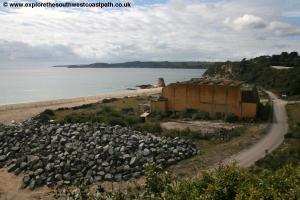
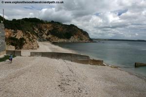
Shortly you come to a little sandy beach which has low cliffs and rocks at low tide and offers fine views out over St Austell bay. Turn right and follow the obvious coastal path along the low cliffs with a golf course on your right. After around half a mile you come to a much large beach. Typically known collectivly as Carlyon Bay it is actually three seperate beaches, Polgaver Beach is nearest, at the eastern edge of the bay, Shorthorn Beach is in the centre and to the west is Crinnis Beach. Sadly this beach suffers from being close to a large urban area and is suffering urbanisation and much of what appears to be sand is in fact stent, waste material from the nearby china clay industry. Follow the cliff top round until you come to the main access road to the beach, by the car park. The back of the beach here was developed in the 1950s with the large building, now derelict in the centre being home to the Cornwall Colliseum and also Gosspis Nightclub. At the time of writing (August 2011) planning permission has just been granted to demolish this eyesore but rather than return the beach to nature it is to be replaced with a 500 apartments crammed in at the back of these three beaches which will leave only a small part of the beach closest to the sea undeveloped and accessible. A real shame to see what could be a beautiful beach spoilt by development. It is hard to imagine a less appropriate use of the site. The apartments will be built between the cliffs and the sea on the beach itself and as such will need protecting by a large sea wall to reduce the risk of flooding. Time will tell whether this is enough to protect it during storms. Also as a result of this development access to the beach may not be available at all times which could impact on the coast path too.
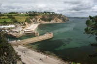
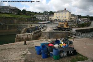
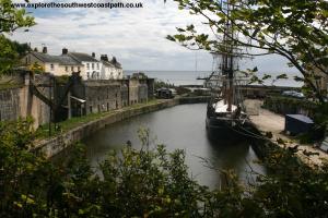
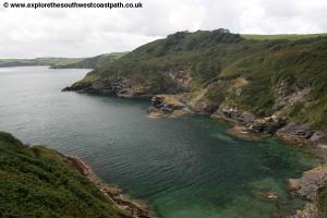
Walk through the car park and at the end take the path between the hedges into a grassy cliff top area. Follow the path west through this soon with the Carlyon Bay hotel on your left. This rathe runattrative 1960s building has been made far prettier by being almost totally covered by plants on the front. Continue past the hotel and it's tennis courts and into another grassy area. This soon ends and the path continues on a narrow path between houses and a hotel on the right and the coast on the left. This briefly runs close to the road before returning to the cliff top and soon turns away from the cliff top passing behind three houses. After these houses the coast path turns back left on a path between fields to rejoin the cliff top on the cliffs above Charlestown. Charlestown is a very pretty place with a small harbour with a protective sea wall at either side and numerous old and attractive buildings, as well as a traditional sailing boat in the harbour. Descend down to the harbour edge. Although there is a bridge over the mouth of the harbour at the time of writing it is closed (and I'm not sure it has even been open to the public), so you follow the right hand side of the harbour along Quay Road to the back of the harbour and continue round it and back to the other side. Here it is advisable to check the signs. The old route of the coast path is west along a cliff top path to Polmear head and it's old fort and then along the cliff top to Lower Porthpean. However due to cliff erosion this path has been closed beyond the path and is not accessible. The diversion is instead to follow the main road on the western side of the harbour (Charlestown Road) until just after Annas Workshop on the left where you turn left along Durporth Road. You follow this road for around half a mile and care is needed as it has no pavement for much of the length. Further west new development means there is a pavement however. Continue to the junction with Porthpean Road and then turn left along this road (there is a pavement on the left hand side), soon passing the hospital on your right. Just past the last of the hospital on the right turn left along Porthpean Beach Road now heading due east. As the road curves to the right near it's end keep ahead on the narrow path to rejoin the coast path where you turn right and follow it passing the back of the beach.
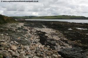
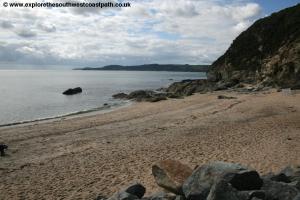
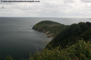
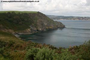
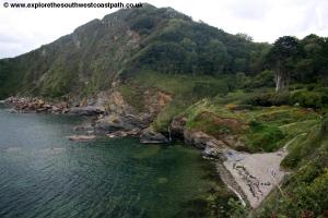
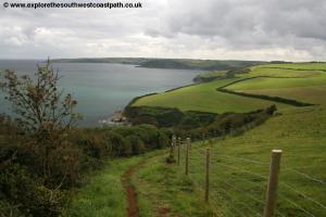
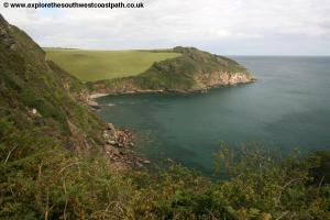
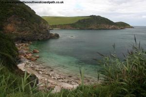
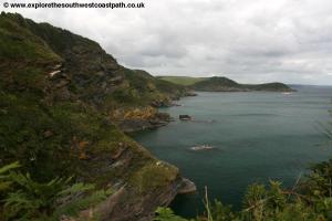
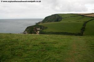
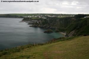
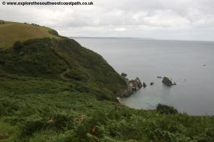
This is an attractive sheltered sandy beach and it's eastern-facing location means it's sheltered from westerly winds. There are minimal facilities here however. Initially you follow the little promenade along the back of the beach (past the now closed ice cream hut) and then follow the road up from the beach passing the sailing club. As this road then turns sharply left keep straight ahead on the obvious surfaced path which rounds the sailing club and then follows the cliff top. Here the coast changes in nature with the low cliffs giving way to steeper cliffs with numerous valleys, most of which require you to descend steeply to sea level and climb steeply back up the other side which makes for a more scenic, but also thougher walk. You follow the field edge path right on the cliff top south from here and soon take the first of the descents just before you reach Phoebe's Point. Climb back up the other side and soon the path widens to a fenced track between the cliffs to the left and fields to the right. The cliffs here soon becomes wooded and form part of Popehaven Cliffs Nature Reserve. The woodland is now classed as access land under the Countryside and Rights of Way Act and as such you can walk through the woodland. There are some tracks down to the waters edge through the woodland (some leading to private houses), but it is best to stick to the coast path here. Soon this track brings you down to a minor road where there is a small car park. Turn left along this road and as the track forks take the left most fork and just past the buildings on the right turn left on the signed footpath to return to the cliff top. You now keep to this path rounding Gerrans Point and soon coming to the southern most tip of St Austell bay, Black Head. This once had a rifle range on it (as marked on some maps), but this no longer exists and you can walk out to the end of the head if you want. It offers stunning views all the way round St Austell bay to your left and to Pentewan and Mevagissey to the right. It is worth taking the path to the end of the headland for the fine views, if you can spare the energy! The cliff top path continues from here heading west (there is a bridleway almost parallel a little further inland) and you soon follow this as you descend back down to sea level at Hallane where there is a house with some attractive gardens nesceld in the steep valley. You follow the path to just behind the house and then cross the little stream and climb steeply back up the other side through the woodland to reach the cliff top. On reaching the cliff top enjoy the fine views as almost immediately you start to descend back to sea level again to cross another little valley.
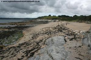
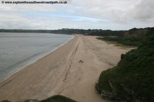
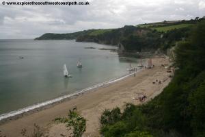
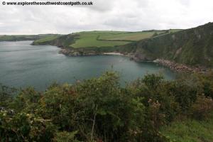
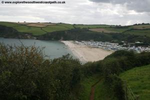
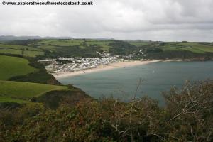
Once over this little valley you climb back to the cliff tops and keep to the very undulating path heading south, soon passing an old quarry, but the path is easy to follow (albeit with plenty of up and down) all the way round to Pentewan. You have good views of Pentewan with it's lovely beach although the huge caravan site just past the harbour rather dominates the view. Here you descend down to the quay and follow the private road in front of the houses to join the public road that rounds the back of the little harbour. Pentewan has a good sandy beach (with a breakwater at it's north end), making it a popular spot to visit. Follow the road around the back of the quay. Once the harbour on your left ends, don't turn left (this leads to the beach, bu tit is not the coast path) but instead continue along the road, passing the car park on the left, marked with a lovely old sign. Keep to this road until it joins the main road, the B3273 between Mevagissey and St Austell. Turn left along this busy road, soon passing the bus shelter on the left. As you come to the entrance to the large caravan park on the left (Pentewan Sands Holiday Park) take this access road (just as the pavement on the main road ends), and almost immediately turn right along the path between the fences that runs parallel to the road. This runs parallel to the road as it twists and turns for around half a mile and near the west edge of the beach you turn left on the signed path away from the road and back to the cliff top. This offers fine views back over the nice beach at Pentewan.
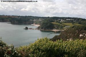
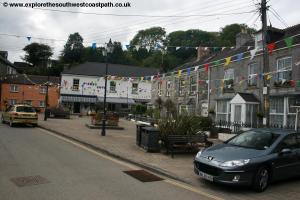
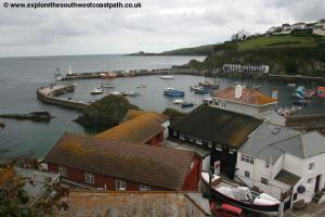
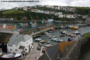
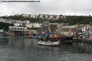
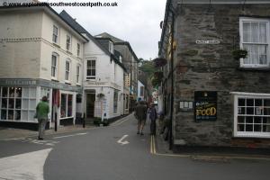
Very soon the coast path descends back down to the sea level at Portgiskey where you had back up the steps at the other side to return to the cliff top. Soon you reach Penare Point where you have fine views to Mevagissey now less than a mile ahead. However before that you have one more descent to close to sea level at Polstreath and as you start climbing back up again a steep staircase on the left provides access to the beach. The coast path however continues out onto a grassy area with the houses on the edge of Mevagissey just beyond. Keep to the cliff edge of this field and at it's end you follow the surfaced path that descends down to Mevagissey and it's harbour. Mevagissey has a large harbour which historically had many fishing boats, but the fishing fleet has declined over recent years. The large harbour is split into an inner and outer harbour and it is possible to get a ferry from here to Fowey at the other end of St Austell bay during the summer. The village itself is well worth exploring. It has many attractive building laid out around the narrow and often steep streets that characterise many coastal villages in Cornwall.
![]()
From Mevagissey buses leave from just past the Driftwood pub. Western Greyhound bus service 526 runs hourly (seven days a week) from here to St Austell station (where there is both a bus and railway station). On Monday – Saturday most buses then continue on to Fowey as route 525 which serves Par (and Par station), providing a through bus from Mevagissey. Although the route number changes at St Austell you can buy a through ticket, just ask the driver. On Sundays you will have to change buses at St Austell station. In addition to this bus service, First Devon and Cornwall service 26 also runs hourly from Mevagissey to St Austell station where you can also change onto their service 25 also to Par and Fowey. An alternative is to alight at St Austell and take the train the one stop east to Par. Trains run roughly hourly, but check the timetable as times vary.
![]()
Here are some photos of the walk. Click each picture for a larger version and description.
 |
 |
 |
 |
 |
 |
 |
 |
 |
 |
 |
 |
 |
 |
 |
 |
 |
 |
 |
 |
 |
 |
 |
 |
 |
 |
 |
 |
 |
 |
 |
 |
 |
 |
 |
|
![]()
Ordnance Survey Landranger maps 105 and 107 cover the coast between Par and Mevagissey and are available locally and nationwide. In addition the links below show the maps of the coast between Par and Mevagissey
![]()